Had a great meal at Stag Inn last night and woke at 7 to sound of a blackcap singing. I noticed that there was a deep ravine by the hobbit hole I’d not noticed previously. Warmed up my overnight oats with some hot water and hoped that would be sufficient for the day ahead. I left the hobbit hut somewhat regretfully at 9:15. They are certainly a good compromise to camping in the cold!
I know today would involve a lot of climbing and for some reason I would say my energy was down today. But I was in no rush and kept plodding on and upwards. By staying at Greg’s Hut I was covering only half the distance we had to last time when going all the way to Alston. I would be doing that tomorrow which was a relief. And I had long wanted to try staying in a bothy so this was my chance.
I had a clear view of all three summits I would be climbing today as I left Dufton behind - an attractive village which I would like to return to some time.
A gradual ascent through fields and an enclosed path with hawthorn and wild apple made a scenic start to the walk. Things got more serious as I crossed the stone bridge across Great Rundale Beck and the steep slopes to Knock Old Man became apparent. I took my fleece off as I was getting too hot. The huge boulders in the dry bed of Swindale Beck told a vivid tale of how strong the floodwaters would be. The path then followed the flank of Knock Hush - the term for the channels formed by man washing minerals out of the ground by forming dams upstream and then letting water rush down the valley eroding the rock and soil as it did so.
At 11:00 I re-entered Moor House Upper Teesdale National Nature Reserve where I had been yesterday. I kept a keen eye out for alpine flowers - at this altitude there were plenty of Teesdale violas. I was up to the first break of slope at 11:30 so stopped for elevenses. The wind was a bit chilly so I put my fleece back on. I was remembering there was a false summit - in fact there were several so I eventually arrived at Knock Old Man (what a name) at 12:40.
For a while there was no clear path and it was clear that there were a number of mine shafts around. But there are enough “carricks” - old marker stones to show the way - that in these conditions it was no problem to make my way over to the road that signals the start of the ascent to Great Dun Fell.
When I joined the road, I took shelter from the wind behind a wall as I was getting chilled and added all the layers I had for this eventuality. I settled down to lunch at 13:10. I was half way and more to Greg’s Hut so I was happy with my progress. I couldn't see any spring gentians, but lots of Teesdale violas. I eventually faced that bitter wind again at 13:50 and was soon up at Great Dun for 14:10.
Mist suddenly rolled in with visibility down to 25m. The forecast was badly wrong - sunny day indeed! I was just below a persistent cloud base and I could see there were swathes of mist to the south and east. However the mist just as suddenly started to lift and caused no issue with navigation.
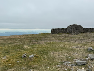
I reached Little Dun Fell at 14:40 - the name is a bit of a misnomer for although it is slightly lower, it has a bit of a kick to it compared to Great Dun. Stone paving for much of the way now took me to the base and most of the way up Cross Fell. On reaching the plateau I realised the mist was starting to roll in again so hurried along to the trig point and shelter for 15:40 so I could see the view across to the Lakes and Morecambe Bay before they disappeared.
Not wanting to chill I didn’t linger but with my glute starting to tighten again I took the descent slowly and arrived at Greg’s Hut at 16:30. My attention was drawn by an alarm call of a small bird, possibly a wheateater to the sight of a pale, large bird which I couldn't immediately identify. I then realised it was a short eared owl, known to occur in these parts. Then I remembered that I'd seen one yesterday above Maize Beck near Birkdale Farm.
A wooden platform provides the base for sleeping and a stove with some coal left was tempting. Unfortunately the paper which was left there was damp and I was unable to get the stove lit. But with my sleeping gear ready and my jet oil quickly turning out hot water for coffee I settled in for the evening - an exciting dinner of smash and tuna tonight!
I was surprised there was some signal so got on with writing these notes to send across to Maria before going to sleep. The sky had finally cleared so the sun was out and I enjoyed the views from this remote but beautiful place. I hoped that I wouldn’t be cold but the forecast was for the temperature to fall to 0. Plenty of layers required tonight!!!


End to End guide says Cross Fell is the highest point on the trail. Nice if it meant it was all downhill now! Hope you will find better accommodation along the Wall than you did at Greg's hut. Guide says Kielder forest is tedious but at least there are easier gradients for a time.
ReplyDeleteMuch love Dad xx